Mineral: `
Locality: Quiruvilca Mine (La Libertad Mine), Quiruvilca District, Santiago de Chuco Province, La Libertad Department, Peru
Description: A BRIEF INTRODUCTION TO QUIRUVILCA
LOCATION:
The Quiruvilca Cu-Pb-Zn district is located in the District of Quiruvilca, Province of Santiago de Chuco, Department of La Libertad, approximately 76 km east of the city of Trujillo.
COLONIAL TIMES
Mining at Quiruvilca has a long and proud history. In 1789 Pedro Jose Gomez de Cal wrote to the Viceroy of Peru informing him that the area contained rich minerals of silver and that three men had made large fortunes there (see Santolalla, F.M., 1909, Estado actual de la mineria en Quiruvilca: Cuerpo de Ingenierias de Minas del Peru, 801. 75, 48 p.). Even today, the area has many surface workings typical of the Spanish and Portuguese mining methods during the Viceregal Years.
MODERN TIMES
Northern Peru Mining and Smelting Co (NPMS), which was a wholly own subsidiary of ASARCO Incorporated (ASARCO) mined the Quiruvilca property from 1925 to 1995. ASARCO initially focused on exploiting the copper bearing veins. Mining at Quiruvilca ceased in 1931, and re-opened in 1940 with the installation of a flotation plant at Shorey. By the late 1960s the Shorey mill was producing copper, lead and zinc concentrates from complex ore stock.
In early 1995 Pan American Silver (PAS) began acquiring the Quiruvilca Mine, and obtained full control of the property between September 1995 and March 1996. Pan American Silver mined the property from 1995 to 2012. (See PAS Annual reports for the period 1995 - 2012)
In June of 2012, PAS sold the Quiruvilca Mine to a Peruvian company called Quiruvilca Ltd, a subsidiary of the Canadian Mining Company called Southern Peaks Mining. In July 2015, Southern Peaks sold the mine to Bolivian citizen Luis Sáenz, who then declared bankruptcy and abandoned the mine in 2017.
In June 2020 Lida Resources Inc. acquired Quiruvilca Mine for $0.2 million USD. Lida plans to change the mining focus at Quiruvilca from a vein type silver mine to a high tonnage gold/copper mine. Perhaps they have plans to convert the mine to a very large open-cut operation.
Today, the Quiruvilca mine is considered an environmental time bomb and a visible source of contamination of the Moche River.
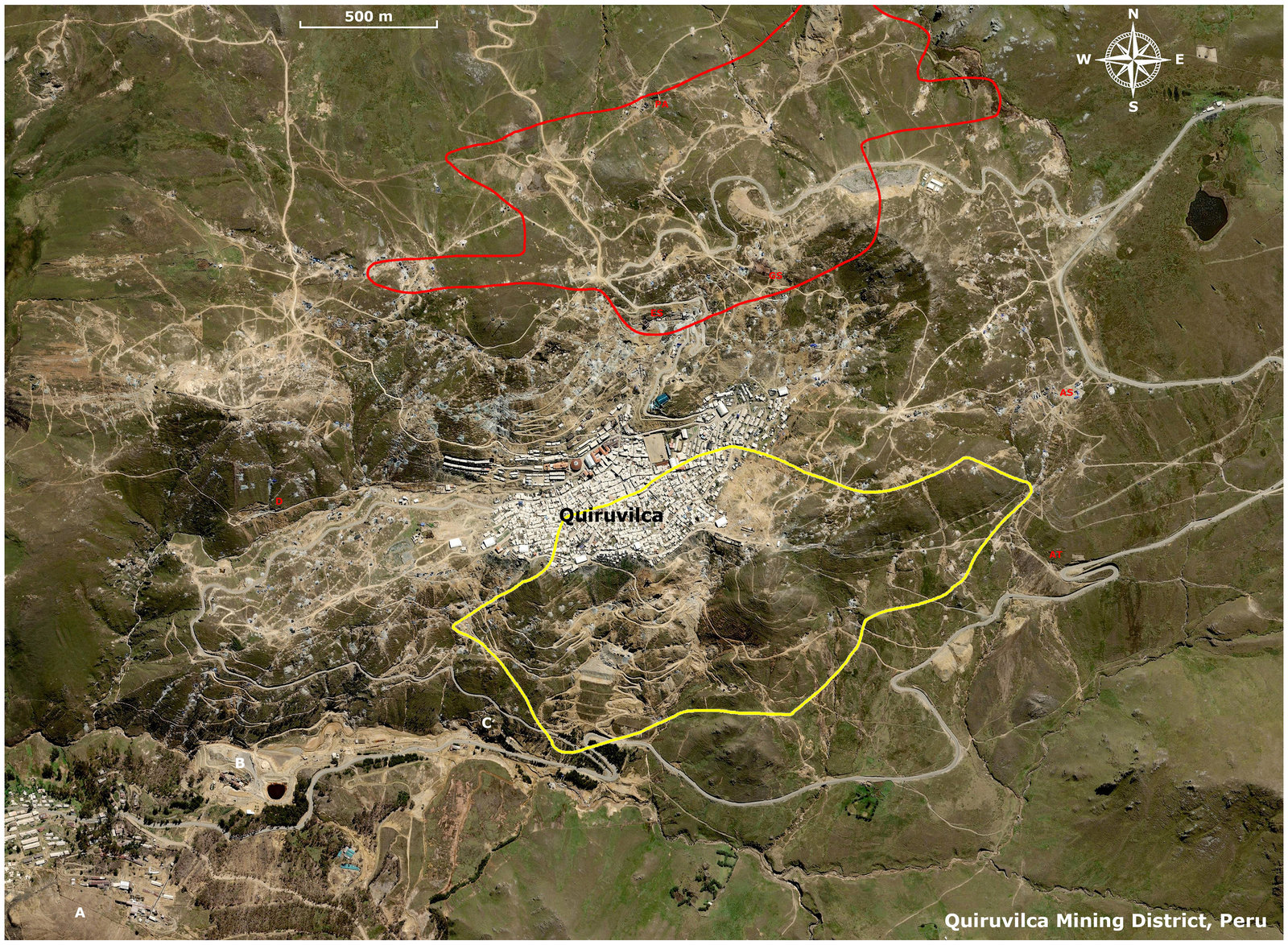
DETAILS TO BE SEEN IN THE AERIAL PHOTO
The resolution of the aerial photograph enables the following features to be seen with clarity just enlarge.
Bottom Left near Shorey
A: Mill and Flotation Plant
B: Ore/Rock Processing Facility
C: Almirvilca Tunnel outlet
West of Quiruvilca
D: 3800 Level Adit
North and East of Quiruvilca
Approximate position of shafts current/past
ES: Elvira shaft
GS: Graciela shaft
AS: Almiranta shaft
AT: Almiranta adit
PA: Papelillo adit
The RED BOUNDARY LINE defines the approximate area of the Northern Mining Zone.
The YELLOW BOUNDARY LINE defines the approximate area of the Southern Mining Zone.
Information based on past Shareholder and Technical Reports provided over the years by ARSACO and PAS.

All pictures, text, design © Forum FMF 2006-2025