silvia
Joined: 10 Oct 2021
Posts: 259
Location: UK


|
 Posted: Jul 02, 2025 16:59 Post subject: Uraninite on The Alligator Posted: Jul 02, 2025 16:59 Post subject: Uraninite on The Alligator |
|
|
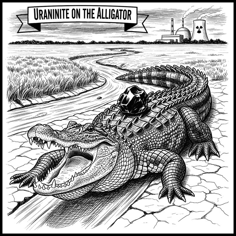
Uraninite on the Alligator
A brief look at the el Sherana Uranium Mine
Introduction
El Sherana, though a minor Uranium producer by current world standards, was one of the richest Uranium deposits in the world, and its discovery, like the chemical element Uranium, attracted much public interest and admiration. Little known to many mineral collectors of the modern era is the fact that the mine produced world-class specimens of Uraninite, meta-Torbernite and Rutherfordine. Many specimens of Uraninite recovered at the mine also contained visible Native Gold. Though the mine is no longer active, the El Sherana leases still host significant economic reserves of Uranium, Gold and Platinum. The site was placed on care and maintenance towards the end of 1964 and it is now part of a national park called kakadu. The mines name is derived from a combination of the names of the daughters (Elvira, Sherryl & Lana) of William Halpin Kay a senior UUNL staff member.
Regrettably there are very few collector quality examples of any of El Sheranas abundant primary and secondary Uranium minerals to be seen in modern era private or public mineral collections.
DISCOVERY
A team of prospectors led by Joe Fischer discovered the El Sherana Uranium deposit in 1954 following a low level aerial scintillometer survey in the South Alligator Valley region of the Northern Territory. The mine operated from 1954 to 1964 under the ownership of the United Uranium No Liability Company (UUNL) a subsidiary of the Northern Uranium Development Company. The Northern Uranium Development Company was a syndicate of private investors based in Melbourne (Australia).
LOCATION
The mine is located about 214 kilometers (as the crow flies) southeast of Darwin. Travel south from Darwin along the Stuart Highway to Pine Creek a distance of about 210 kilometers. Then travel north-east along the Kakadu highway (A21) for about 63 kilometers and turn right onto Gimbat Road and travel a further 28 kilometers to the mine. The old El Sherana camp will be on the left. Access to the mine is gained by a gravel track from the camp along Stag Creek. The main open cut is about 1 kilometer east of the old El Sherana mining camp and approximately 120 meters above the floor of the South Alligator River valley.
LOCAL GEOLOGY
The South Alligator River valley is dominated by a belt of tightly folded metasediments of the early Proterozoic era. The belt trends north-west for a length of about 60 kilometers with a width of approximately 10 km. The dominant strata in the region have been subjected to considerable erosion creating ridges as high as 300 metres. The tops of the ridges host felsic volcanics and sandstone from the early Proterozoic to Middle Proterozoic era. Most of the uranium deposits in the region occur within narrow basins of felsic volcanics and sandstone along a belt that trends north-west.
Laminated ferruginous shales host the primary ore-body at El Sherana, which occurs along a bedded fault contact with incompetent graphitic shales. The ore-body has a discontinuous tabular shape. In the vicinity of the ore-body the shales are severely fractured and dip in a south-easterly direction at about 70 degrees. Reddish brown cherty breccias are also associated with the ore body and the colour of the breccia is due to dust size particles of hematite. The breccia hosts irregular veinlets of quartz and chalcedonic silica. These veins often contain crystals of pyrite and small grains of Uraninite coated with meta-Torbernite.
For a detailed discussion of the Regional geology review the work of Friedmann in Stratigraphy, Sedimentology and Tectonic Evolution of the 1.86Ga El Sherana and Edith River Groups, Northern Territory, Australia by S. Julio Friedmann, Thesis, MIT, June 1990.
MINING HISTORY A Brief Review
URANIUM PRODUCTION
Shortly after the initial discovery of the deposit in 1954, portable sleeping facilities for the workers were constructed on residential lease 2A beside Stag Creek. Further exploration of the El Sherana prospect then began in earnest. In 1956 a gravity separation plant was constructed about 2 kilometers SE of the main camp to process Uranium ore on site.
In 1956 UUNL signed a contract to supply 100 long tons of 50% Uraninite concentrate (U3O8) to the United States Combined Development Agency (CDA). Initial work focused on hand-screened Uraninite ore but after the construction of the gravity separation plant, the bulk of the contract was fulfilled with concentrates. The contract with the CDA was finalized in December 1957.
In April 1958 after two years of negotiations UUNL signed a contract with the United Kingdom Atomic Energy Commission (UKAEC) for the supply of 570 long tons of U3O8 at a rate of 100 long tons per annum.
In 1959, United Uranium N.L purchased the Northern Hercules Mill at the Moline mine, some 50 kilometers to the west of the El Sherana site and converted it to a solvent extraction Uranium plant. The processing of ore from El Sherana began at the Moline mill in May 1959.
From 1956 to the closure of the mine in 1964, El Sherana and El Sherana West collectively produced the greatest output of U3O8 of all the Uranium mines operating in the South Alligator Valley region.
PRODUCTION DATA
Some production figures (expressed as SI units) for the mine are given in the tables below.
PRODUCTION FIGURES
PROD U3O8
MINE (Ton) (kg/t) (kg)
El Sherana 1956-1959 39,054 5.20 202,935
El Sherana West 1961-1964 21,658 8.20 177,425
ORE IN SITU
DEPOSIT TON U3O8
(kg/t) (kg)
El Sherana 2,032 1.79 3,629
El Sherana West 8,596 6.18 53,149
GOLD PRODUCTION
From the very beginning of the mine the auriferous nature of the Uranium ore was well known. Ore residues from the gravity separation plant were trucked to the Rum Jungle plant for additional processing, and in 1957 the first Gold bar was cast. From then on Gold became an important by-product of mining at the El Sherana mine.
Once the UKAEC contract had been fulfilled Uranium mining at El Sherana was suspended. Unable to secure any additional Uranium oxide export contacts, UUNL decided to convert the mill at Moline to a Gold processing facility. Initial processing focused on tailings derived from the Uranium ore mined in the South Alligator valley Uranium field.
Between 1954 and 1964 approximately 143,000 long tons of Uranium ore were recovered from mines in the South Alligator Uranium field, with approximately 60,000 long tons being taken from the El Sherana leases. The El Sherana ore processed at Moline yielded 8,900 troy ounce of Gold, equivalent to approximately 5.45 grams of Gold to the metric ton of ore.
While the Moline mill was processing the tailings from previous Uranium mine work, the UUNL investigated the feasibility of converting the El Sherana mine into a major Gold producer.
UUNL commenced a preliminary drilling program to determine the extent of the Gold mineralization at El Sherana. UUNL had always felt that the Gold ore bodies at El Sherana were much more extensive than the Uranium ones, a fact that was confirmed by exploration work conducted by BHP in the late 1980s.
Due to a reduced value in the price of Gold, approximately $35AUD per troy ounce at the time, the plan to relocate the Moline mill to El Sherana became an uneconomic venture and as a consequence all plans to mine Gold at El Sherana were suspended.
By the end of 1965 the Moline mill had finished processing all the Uranium residues from the mines in the South Alligator valley region. It was then used to process Silver, Lead and Zinc ore from the nearby Evelyn mine.
Exploration and assay work conducted by BHP in the late 1980s indicated that the contained Gold in the El Sherana ore-body ranged from "trace" levels to 15g/t with sporadic high values of more than 30g/t. The work by BHP also indicated the presence of Platinum and some Palladium within the El Sherana leases.
MINE LAYOUT
EL SHERANA
Initial exploration work focused on inclined diamond and vertical wagon exploration drilling followed by shaft sinking, adit driving and preliminary stoping.
Between 1956 and 1957 preliminary mining exploration discovered the existence of irregular lenses of very high grade Uraninite ore to a depth of 30 metres. The ore was enclosed in an extensive envelope of lower grade oxidised ore.
Two exploratory shallow shafts were sunk to access the rich ore. Initially high grade Uraninite ore was extracted from the 210 metre and 195 metre levels by selective cut and fill stoping. The Uraninite lenses present within the 210 metre level had a maximum width of about 17 metres while those uncovered in the 195 metre level had a maximum width of 30 metres. The size of the Uraninite ore body made open cut mining a viable option, and the old open cut is still visible in modern day aerial photographs.
EL SHERANA WEST
A significant radioactive anomaly over carbonaceous shales was discovered on the slopes of a small valley below the main El Sherana open cut in the late 1950s. It was subsequently shown that this region also contained rich deposits of Uraninite. About 180 metres below the main El Sherana open cut another smaller open cut was developed and the west mine operated from 1961 to 1964.
The steep topography made the extraction of ore more amenable to underground mining techniques, and the rich ore was removed using cut and fill stoping which continued on the 95 metre level from an underlie shaft sunk on the base of the open cut. To access the additional high grade mineralized zones, adits were driven along the 115, 145 and 150 metre levels.
MINERALIZATION
URANINITE
The Uranium mineralization at the El Sherana leases was shown to occur over a 400 metre strike length with a vertical depth exceeding 180 metres and widths of up to about 30 metres. Uraninite frequently occurred as massive segregations, radiating columnar aggregates, veins and disseminations associated with minor amounts of Cobalt and Nickel Arsenides, Arsenopyrite, Pyrite, Marcasite, various Copper sulphate species, Galena and Clausthalite. The primary ore was often enclosed in an extensive envelope of lower grade oxidised ore. Bulbous isolated masses of Uraninite weighing more than 50 kilograms were very common at the El Sherana mine. It is a noteworthy fact that El Sherana yielded the largest single piece of Uraninite ever produced in the world. It weighed 850 kilograms (1,856 pounds).
Some specimens (>10 kg) of Uraninite recovered at the mine often contained networks of radial and concentric shrinkage cracks containing quartz, secondary Uranium minerals, selenides, sulphides and/or native Gold.
The colloform habit was the most common form exhibited by the Uraninite. Some collector quality specimens resembled kidney ore and in some of the larger and better specimens seen at the mine, the radius of curvature of the individual lobes exceeded 15 cm.
Some of the Uraninite specimens recovered from the mine also contained voids containing crystals (ca. 1-2 mm) of Johannite. Other specimens of Uraninite were encased in halos of Gummite.
SECONDARY URANIUM MINERALS
The mine contained many secondary Uranium minerals resulting from the oxidation of the primary ore. Thus the main ore bodies contained extensive seams and masses of uranium ochres containing complex mixtures of secondary uranium minerals oxides, carbonates, sulphates, phosphates and silicates.
The list of identified secondary minerals included but was not limited to the following species: Autunite, Becquerelite, Dumontite, Johannite, Kasolite, meta-Autunite, meta-Torbernite, meta-Zeunerite, Renardite, Rutherfordine, Torbernite, Saleeite, Soddyite and Uranopilite. Of these only meta-Torbernite and Rutherfordine occurred in sufficient isolated quantities (hand-sized specimens) to be of interest to mineral collectors of the era.
Metatorbernite - Cu(UO2)2(PO4)2(H2O)8
Metatorbernite occurred as well-formed, apple green euhedral crystals to 10mm filling large cavities in matrix. Occasionally the meta-Torbernite occurred within veins intersecting the Uraninite.
At the El Sherana main open cut well defined Metatorbernite crystals, some to 10 mm in width, occurred along fracture faces within an assemblage (Koolpin stratum) composed of interbedded chert, ferruginous siltstone, carbonaceous shale and siltstone.
Rutherfordine, UO2CO3
Rutherfordine was the most abundant of the secondary Uranium minerals found at El Sherana. It occurred as fine-grained and earthy encrustations on the surface of the Uraninite. Occasionally voids within the Uraninite, some a few centimeters in diameter, were filled with bladed aggregates of long slender crystals of Rutherfordine. Veins of Rutherfordine, some several millimetres wide, occurred in shrinkage cracks and stress fractures within the Uraninite.
Massive and vuggy Uraninite from the El Sherana main open cut often contained veins and masses of Rutherfordine associated with meta-Torbernite. The chert, a common rock found in the main open cut, contained Rutherfordine as thin coatings in fractures and joint planes also associated with meta-Torbernite.
SOME NOTES ON MISLABLED EL SHERANA URANIUM MINERALS
Carnotite was not a mineral species observed at the El Sherana mines. Soddyite, Phosphuranylite and Vandendriesscheite were associated with Uraninite at the Pallette mine. Uranopilite did occur as a minor accessory mineral with some specimens of Uraninite from the El Sherana mine. Saleeite and Uranophane were seldom seen associated with any specimens of Uraninite from any of the mines within the South Alligator Uranium field.
| Description: |
Country Map Photo
The Northern Territory occupies the central position in the northern section of the Australian continent. Its coastline meets the Timor Sea, Arafura Sea, and the Gulf of Carpentaria to the north. To its west lies Western Australia, while South Australia forms its southern border. Queensland defines its eastern boundary. This diverse geography gives the Northern Territory ever changing landscapes, from tropical coastlines in the north to the arid desert regions in the south. The El Sherana mine is located in the South Alligator River valley region of the Northern Territory. The insert shows the geographical location of the Northern Territory in relation to the rest of the continent.
It is interesting to note that the term Alligator in reference to the Alligator Rivers Region of the Northern Territory and its three main rivers (East, South, and West Alligator), originated from a mistake made by Lieutenant Phillip Parker King. During his ground-breaking explorations between 1818 and 1822, he encountered numerous crocodiles in the estuaries of these rivers. In his journals, he noted the abundance of these large reptiles and mistook them for alligators, a species not indigenous to Australia. Thus he named the rivers "Alligator Rivers." Despite the scientific inaccuracy, the name stuck and is still used today to describe the region. |
|
| Viewed: |
250 Time(s) |

|
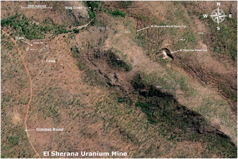
| Description: |
Location Photo
Map of the location of the El Sherana mine within the South Alligator Uranium field. About 2 kilometres south of the main camp via Gimbat road is the location of the gravity Separation plant which was demolished sometime in the late 80s or early 90s. The location of the site of the plant is still clearly visible in recent (ca. 2023) aerial photographs.
The area contains numerous deposits of Uranium which were exploited from about 1953 to 1970. The first discovery of Uranium in the area occurred at Coronation Hill some 13 kilometers southeast of the El Sherana mine. The discovery was made in 1953 on Coronation day (June 2nd) by B. P. Walpole a Geologist working for the Bureau of Mineral Resources.
The most colourful deposit in the whole Uranium field was the Palette mine located about 7 kilometers south-east of El Sherana. It was reached by a winding, precipitous road whose access was often cut by the flooding of the South Alligator River during the wet season. It was at the same elevation as El Sherana. The Palette mine was a large fan shaped deposit adjoining a sheer white cliff face. Joe Fisher, mining consultant and pioneer of Uranium mining in South Alligator River, named the site palette because he said the Uranium mineralisation reminded him of the colourful daubs of paint one might see on an artists palette. Eyewitness accounts spoke of a truly colourful place glittering magnificently in the sunlight where the hues of blackish Uraninite, orange Gummite, lime-green Autunite, apple-green Torbernite and dark-yellow Soddyite were clearly visible even from a distance of a hundred metres or more.
John Webb, who was the field Superintendant with the Australian Atomic Energy Commissions at the time (1958) stated that many of the secondary Uranium minerals recovered at the Palette mine were superb collector pieces too good to be broken up and sold as ordinary Uranium ore. Regrettably few if any collector quality specimens from this mine can be seen in modern day mineral collections.
Other mines in the area include but are not limited to Koolpin, Scinto, Cliff Face, Skull and Saddle Ridge. UUNL records indicate that El Sherana was the largest producer of Uranium ore in the region. |
|
| Viewed: |
250 Time(s) |

|
| Description: |
Aerial Photograph of the El Sherana Mine
Shown is an aerial photograph of the current status of the El Sherana mine. Visible is the camp containing a few derelict buildings. The main open cut is still intact but some areas of the open cut appear to be filled in by natural erosion of the surrounding terrain. Though the area was said to have been rehabilitated sometime in the late 80s or early 90s the aerial photograph indicates that this was either not done or the work was sub-standard.
The El Sherana west open cut is still visible, but not as well-defined as seen in a photograph taken in 1963 by UUNL. The area is now overgrown with new and abundant vegetation, which I think, might have a fondness for Uranium. It is also likely that the area may have succumbed to subsidence or natural erosion of the benches. There are no records indicating that UUNL filled in the west open cut after the mine was put on care and maintenance in 1964. Photographs taken by BHP in the late 80s show that the open cut was heavily overgrown with new flora native to the South Alligator River valley region. According to BHP staff (private communication) the open cuts provided many good homes for the abundant native fauna. Crocodiles you ask, most likely, but who knows?
The site of the Uranium Processing plant some 2 kilometres SE of the main camp (not shown in the above aerial photograph) was covered in soil in the late 80s or early 90s. The buildings on the site were demolished and the remains buried. This attempt to rehabilitate can be seen in aerial photographs but it would appear that even here the mine is fighting back.
Height above sea level for some locations is given in metres.
Main open Cut Digital GPS location: -13.50932, 132.52067 |
|
| Viewed: |
250 Time(s) |
|
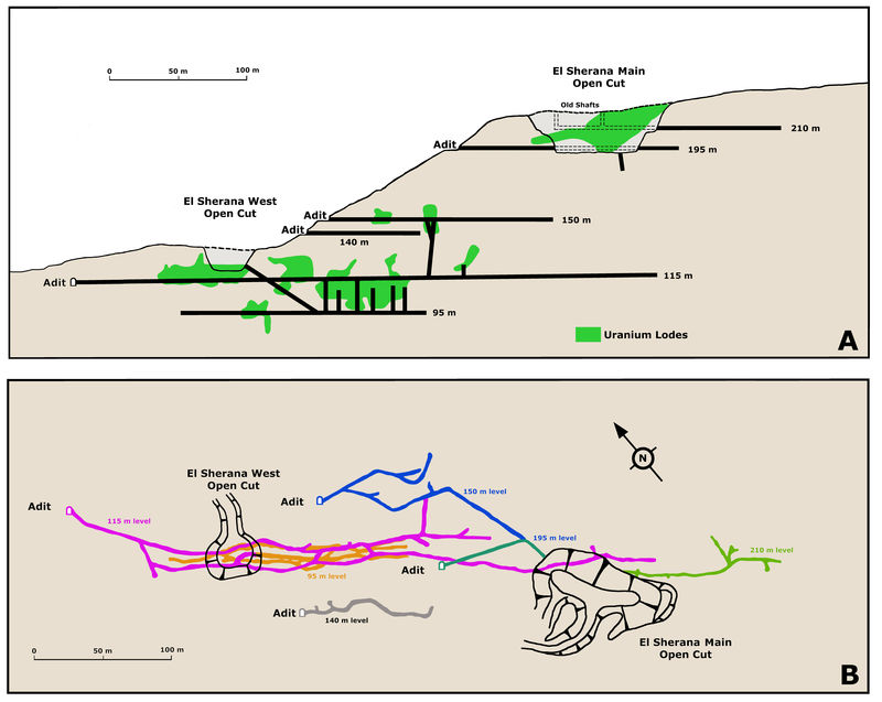
| Description: |
Diagram of the Main Mine Working
Diagram A shows a longitudinal section of the mine in terms of the relative positions of all the main adits and open cuts. Diagram B shows the relative positions of the open cuts and the underground workings. The extension of the 195 metre level that lies SW of the main open cut is directly beneath the 210 metre level. All structures have been referenced to height above sea level. These diagrams are based on unpublished reports, UUNL maps, private communications and UUNL company note books. |
|
| Viewed: |
250 Time(s) |
|
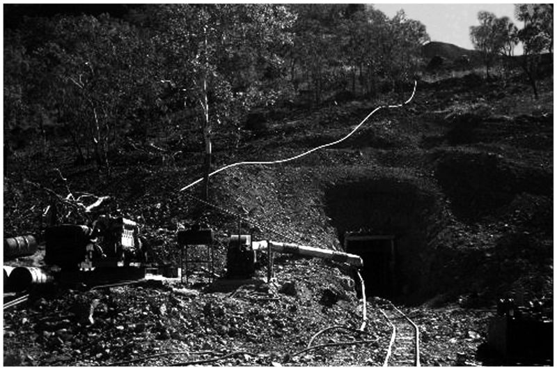
| Description: |
El Sherana Mine Photo showing Adit
An old adit set into a hill at El Sherana, note tracks leading into an adit (perhaps the 195 metre level) and the visible water pipes and machinery, El Sherana, NT late 1950s. (Photo courtesy of R. Fisher) |
|
| Viewed: |
250 Time(s) |
|
| Description: |
El Sherana West Photo
El Sherana West Open cut ca. 1963. The small open cut was set in some very steep terrain. Clearly visible in the background is the adit leading to the incline shaft which accessed the lower levels from which the bulk of the high grade Uraninite ore was extracted. In the foreground is a jeep bearing the logo of the United Uranium N.L. Company. (Photo courtesy of N. Murphy) |
|
| Viewed: |
253 Time(s) |

|
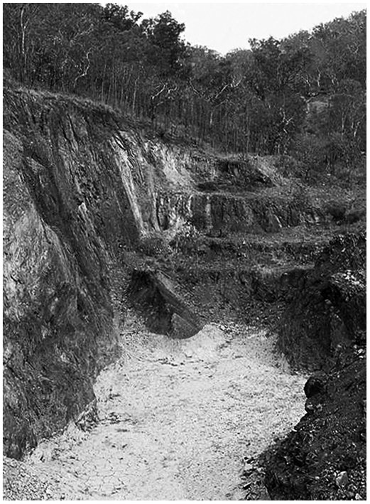
| Description: |
El Sherana Photo
Part of the El Sherana open cut ca. 1988. (Photo courtesy of BHP) |
|
| Viewed: |
250 Time(s) |
|
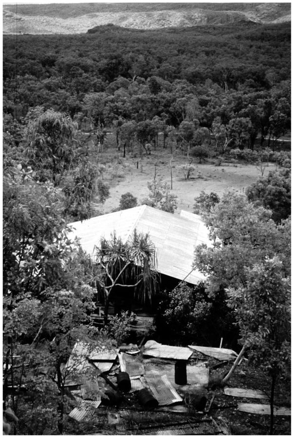
| Description: |
El Sherana Processing Plant
Photo showing part of the derelict remains of the El Sherana mines Gravity Separation Plant. The plant was constructed in 1956 to process the rich Uranium ore extracted from the nearby mines. Gimbat Road is in the background. (Photo courtesy of S. Kerber) |
|
| Viewed: |
251 Time(s) |
|
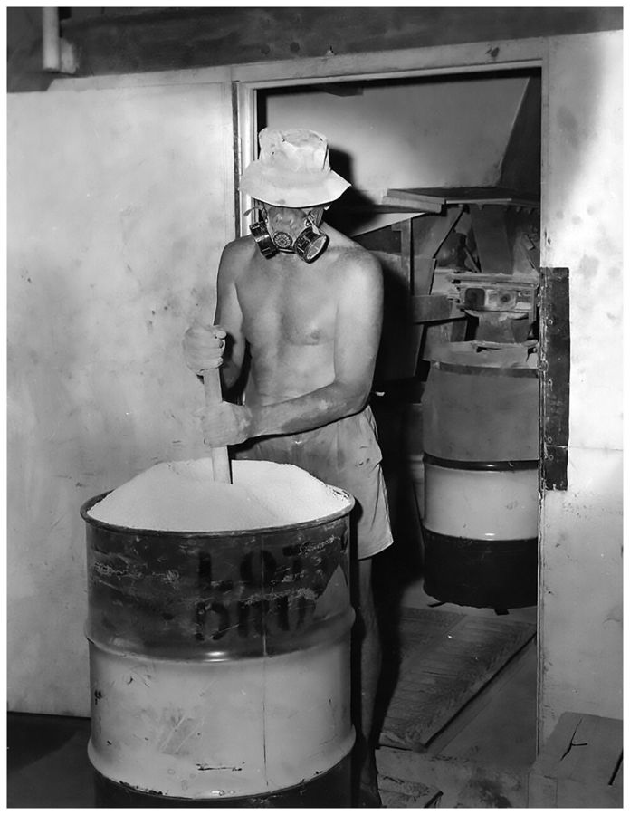
| Description: |
Processing El Sherana Uranium ore at moline
Shown is a photo of a worker settling the Uranium ore concentrate into an appropriate steel container in a well-ventilated area. United Uranium N.L., Moline, Northern Territory, 1963. (Photo courtesy of J. Taylor)
The light colour of the product shown in the photo is indicative of Ammonium Uranyl Carbonate (AUC), commonly known as yellow-cake. An alternative compound supplied to the Nuclear Energy Industry is called AUD which is an abbreviation for Ammonium Diuranate, (NH4)2U2O7. AUD is much darker in colour than AUC with a greenish brown hue. For a detailed discussion on the solvent extraction of Uranium from Uranium ores see Ullmann's Encyclopedia of Industrial Chemistry, 40 Volume Set, 7th Edition, Section U, Uranium, Uranium Alloys, and Uranium Compounds; ISBN: 978-3-527-32943-4. |
|
| Viewed: |
251 Time(s) |
|
| Description: |
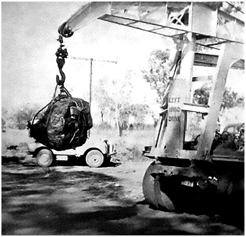
Uraninite being loaded
El Sherana yielded the largest single piece of Uraninite ever produced in the world. It weighed 850 kilograms (1,856 pounds). It was recovered at the El Sherana mine in May 1956. The specimen was purchased by the Australian Atomic Energy Commission for exhibition in Sydney. In the photo the specimen has been hoisted with the aid of a portable crane for loading into a suitable transport vehicle. (Original photo courtesy of F. Jones) |
|
| Viewed: |
250 Time(s) |
|
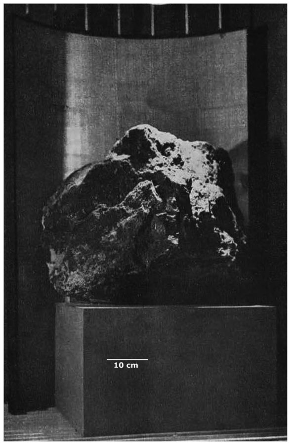
| Description: |
El Sherana Uraninite at the Australian Museum
Between 1961 and 1983 the Sydney based Australian Museum proudly exhibited a huge specimen of El Sherana Uraninite. At the time it was the largest specimen of Uraninite ever recovered, and weighed approximately 850 kilograms. It measured 48 cm high and 46 cm wide. The specimen was recovered at El Sherana in May 1956. The potential radiation threat from this superbly wonderful and scientifically priceless specimen was thoroughly assessed by Health and Safety experts from the New South Wales Health Department. These experts stated and I quote after measuring the amount of radiation from this big specimen, to obtain the maximum permissible dosage a member of the public would have to stand on the spot from where the specimen can be viewed for half an hour every day for the rest of his life. Therefore, the amount of radiation received by any member of the public from casual viewing is quite negligible. End of quote. As an additional precaution an exhaust fan was installed in the outside wall behind the specimen to remove the small amount of Radon emitted from the outer most surface (ca. 1-2 mm) of the specimen.
Sometime in the early 1980s The Australian Museum gave the specimen to ANSTO for safe keeping at their Lucas Heights facility. According to ANSTO and its regulatory partner ARPANSA, the current location of the specimen is unknown.
Another similar, but smaller, specimen of Uraninite from El Sherana was displayed in the British Museum in London, but its current whereabouts is also unknown.
El Sherana Uraninite was dated at about 1800 Ma.
Before the El Sherana specimen was recovered, the previous weight record for a single specimen of Uraninite was held by the Shinkolobwe Mine in the Katanga Province of the Democratic Republic of the Congo. The Shinkolobwe specimen weighed 750 kilograms. (Original Photo courtesy of R. Chalmers) |
|
| Viewed: |
251 Time(s) |
|
| Description: |
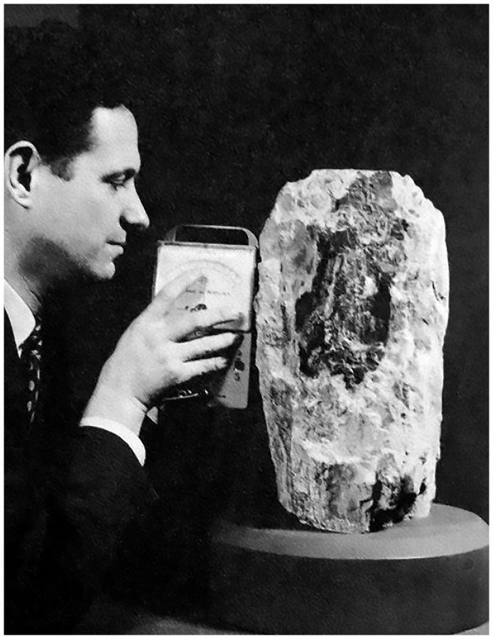
Uraninite at the AMNH The American Connection
Included for comparison is a photograph of what might be the third largest Uraninite specimen to be publically exhibited in recorded history. The specimen weighed just over 60 kilograms and consisted of an inner core of Uraninite covered in a deliciously thick layer of Schoepite. It was exhibited for many years at the American Museum of Natural History (AMNH). In the photograph Dr. Brian H. Mason (1917-2009) Curator of the Department of Physical Geology and Mineralogy at the Museum (1953-1965) can be seen measuring the radiation from the superb specimen. The specimen was donated to the AMNH in 1955 by Vernon J. Pick and it came from the Pick's Delta Mine, San Rafael Swell Mining District, Emery County, Utah, USA. What a fine specimen to have in a private collection the mineralogical stories it could tell and the secrets it could reveal truly amazing and absolutely beautiful!
I think some folks might find the following piece of historical trivia interesting. Dr. Mason was an expert on meteorites and was the first scientist to suggest that some meteorites found in Antarctica were in fact moon rocks. Between 1962 and 1965 Dr. Mason took part in several Australian-American expeditions to the clay pans in central South Australia in search of Australites (Tektites). The Australian team was led by R.O Chalmers, Curator of Minerals at the Australian Museum and the man largely responsibility for the acquisition of the fantastic specimen of Uraninite from El Sherana. Dr. Mason also had two minerals named in his honour, Brianite a Sodium-Calcium-Magnesium phosphate mineral (Na2CaMg(PO4)2) and Stenhuggarite a rare Calcium-Iron-Antimony mineral (CaFeAs2SbO7). The mineral name Stenhuggarite is a clever use of the Swedish word Stenhuggare for stonemason honouring Dr. Masons work as the proverbial stone man. Asteroid 12926 Brianmason is also named in his honor. In 1965 he became Curator of Meteorites in the Department of Mineral Sciences at the Smithsonian Institution in Washington, retiring in 1984. (Photo courtesy of B. Kramer). |
|
| Viewed: |
251 Time(s) |
|
| Description: |
Uranium Specimens in storage at the AMNH
On the right is a 60 kg specimen of Uraninite with Schoepite from Pick's Delta Mine, San Rafael Swell Mining District, Emery County, Utah, USA. It is the same specimen shown in the earlier picture which featured Dr. Brian H. Mason. Just look again at that deliciously thick layer of Schoepite with some Uraninite just visible in the lower right hand corner superb!
On the left is a 15 kg specimen of Uraninite with Schoepite from the Lookout No. 22 claim, Marshall Pass, Saguache County, Colorado, USA. Both specimens are now in storage at the AMNH (Photo courtesy of AMNH) |
|
| Viewed: |
250 Time(s) |

|
|
|
silvia
Joined: 10 Oct 2021
Posts: 259
Location: UK
|
| Posted: Jul 02, 2025 17:01 Post subject: Some Facts About Uranium Minerals |
|
|
Some facts about Radioactive Minerals
US health Physics Society
HPS - Answer to Question #573, "Ask the Experts" Topic; Is Autunite Dangerous?
HPS - Answer to Question #1449, "Ask the Experts" Topic; Is Gamma Radiation from Autunite Dangerous?
HPS - Answer to Question #5970, "Ask the Experts" Topic: Exposure Hazards - I sniffed an Autunite specimen.
HPS - Answer to Question #9222, "Ask the Experts" Topic: Radon from Uraninite specimens.
HPS - Answer to Question #11680 "Ask the Experts" Topic: Should I remove a Uraninite specimen from my house? No! Dose readings based on GM/Scintillator Counters are misleading.
PRACTICAL MATTERS
Alysson Rowan, Here be Dragons, The Care and Feeding of Radioactive Mineral Species, 2017; self-published.
Alysson Rowan, Undoing the demonisation of radioactive minerals, 2017; self-published.
Identifying and managing radioactive geological specimens, Monica Price, Jana Horak & John Faithfull, Journal of Natural Science Collections, Volume 1, pp. 27-33, 2013.
Living with Radiation: The First Hundred Years: Paul Frame and William Kolb., Syntec, Maryland, USA, 2012.
Colin Keay, PhD, DSc., Nuclear Energy Fallacies - Here are the Facts That Refute Them, The Enlightenment Press, 2005.
Colin Keay, PhD, DSc., Nuclear Common Sense - Opportunity for Prosperity, The Enlightenment Press, 2003.
Colin Keay, PhD, DSc., Nuclear Radiation Exposed - A Guide to Better Understanding, The Enlightenment Press, 2004.
RADON EMISSION FROM RADIOACTIVE MINERALS
Krupp, Katherine & Baskaran, Mark & Brownlee, Sara-Jane, Radon emanation coefficients of several minerals: How they vary with physical and mineralogical properties, American Mineralogist, 102, 1375-1383, 2017.
Haquin Gustavo, Yungrais Zohar, Ilzycer Danielle, Zafrir Hovav and Weisbrod Noam; Detailed effects of particle size and surface area on Rn(222) emanation of a phosphate rock, Journal of Environmental Radioactivity; 180, 77-81, 2017.
Akihiro Sakoda Yuu Ishimori, Kiyonori Yamaoka, A comprehensive review of radon emanation measurements for mineral, rock, soil, mill tailing and fly ash, Applied Radiation and Isotopes 69 14221435, 2011.
Michael Kitto and John Green, Emanation from granite Countertops, 2005 International Radon Symposium, San Diego, CA.
R. Randall Schumann; The Radon Emanation Coefficient: An Important Tool for Geologic Radon Potential Estimations, U.S. Geological Survey, Denver, Colorado, 40-43, 1993.
S. Ralph Austin and Robert F. Droullard, Radon Emanation from Domestic Uranium Ores Determined by Modifications of the Closed-Can, Gamma-Only Assay Method, Report of Investigations 8264, United States Department of the Interior, Bureau of Mines, 1978.
|
|