| View previous topic :: View next topic |
| Author |
Message |
rockandboulders
Joined: 22 Aug 2011
Posts: 10
Location: Wisc


|
 Posted: Dec 22, 2011 17:31 Post subject: Wisconsin Gravel Pit - Possible Glacier Deposit Layers? Posted: Dec 22, 2011 17:31 Post subject: Wisconsin Gravel Pit - Possible Glacier Deposit Layers? |
|
|
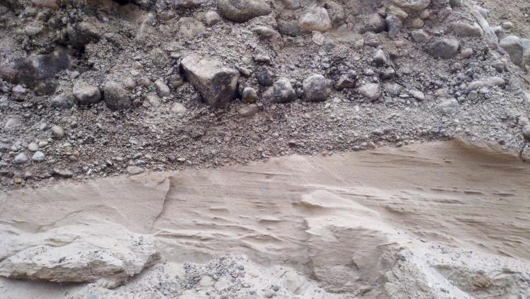
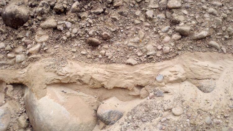
Hi, I have taken a few pictures of some layers of materials in the gravel pits I work at.
The main picture shows a rocky layer with a bunch of rocks and then below it is a pure sand layer with some veins in the sand layer running in different angles than the line between the rock and sand layer.
What my real question is is what caused there to be rocky layers and then pure sand layers here?
Those layers alternate down into the ground further than the picture shows alternating from rock to sand about 4 times 10 - 15 feet lower.
| Description: |
|
| Viewed: |
9468 Time(s) |
|
| Description: |
|
| Viewed: |
9503 Time(s) |
|
|
|
| Back to top |
|
 |
Susan Robinson
Joined: 05 Aug 2010
Posts: 163
Location: Hancock, MI
|
| Posted: Dec 22, 2011 18:08 Post subject: Re: Wisconsin Gravel Pit - Possible Glacier Deposit Layers? |
|
|
What the layers of stones and sand show in the gravel pit is probably either alternating advance and recession of a glaciers, or changing water flow rates in a small river or stream. Judging from the great variation in the size of boulders in some layers, it seems like those layers were probably deposited by a glacier during one of the ice advances during the Pleistocene (about 10 - 40,000 years ago).
The sandy layers between the layers of boulders and coarse material could have formed by waters flowing under the glacier or melt waters coming from the front edge of the glacier. A slow-flowing stream can only carry very tiny particles, like sand grains; a glacier's ice can hold boulders of nearly any size and deposits them when it melts. The angles of deposition within the sand are evidence of changing directions of water flow, or possibly, changing wind direction in a dry sand bed (known as cross-bedding).
I hope this information helps explain the deposits in the sand and gravel pit.
_________________
Susan Robinson |
|
| Back to top |
|
|
Woody Thompson
Joined: 08 Mar 2010
Posts: 60
Location: Maine
|
| Posted: Jan 02, 2012 21:06 Post subject: Re: Wisconsin Gravel Pit - Possible Glacier Deposit Layers? |
|
|
As Susan noted, this sand and gravel looks like it was deposited by glacial meltwater. It would help to see overview photos showing more of the gravel pit, but the interlayered sand and gravel resulted from alternations in stream current velocity. The thin layers (beds) in the sand indicate successive pulses of deposition. There was an episode of erosion at the top of the sand, just before the gravel was laid down on top.
The overall deposit of sand and gravel could have accumulated very rapidly (days to weeks or months) as "outwash" in front of the melting glacier, or maybe as an esker formed in an ice-walled tunnel at the base of the ice. Eskers typically now appear as ridges marking where the tunnels used to be. Further info is needed for us to interpret what happened here. I expect the Wisconsin Geological Survey could tell you lots more, and might even have surficial geologic maps showing the glacial and postglacial sediments in the pit area.
Susan, forgive me for jumping in here when you've already answered the question well, but as a glacial geologist I couldn't resist!
_________________
Woody Thompson
Maine Geological Survey |
|
| Back to top |
|
|
Susan Robinson
Joined: 05 Aug 2010
Posts: 163
Location: Hancock, MI
|
| Posted: Jan 03, 2012 06:59 Post subject: Re: Wisconsin Gravel Pit - Possible Glacier Deposit Layers? |
|
|
No problem, Woody. Your expertise is much appreciated. See you in Rochester in the spring,
Susan
_________________
Susan Robinson |
|
| Back to top |
|
|
|