| View previous topic :: View next topic |
| Author |
Message |
vic rzonca

Joined: 18 Nov 2008
Posts: 820
Location: MA


|
 Posted: Apr 15, 2020 07:35 Post subject: Mines and mineral Localities Posted: Apr 15, 2020 07:35 Post subject: Mines and mineral Localities |
|
|
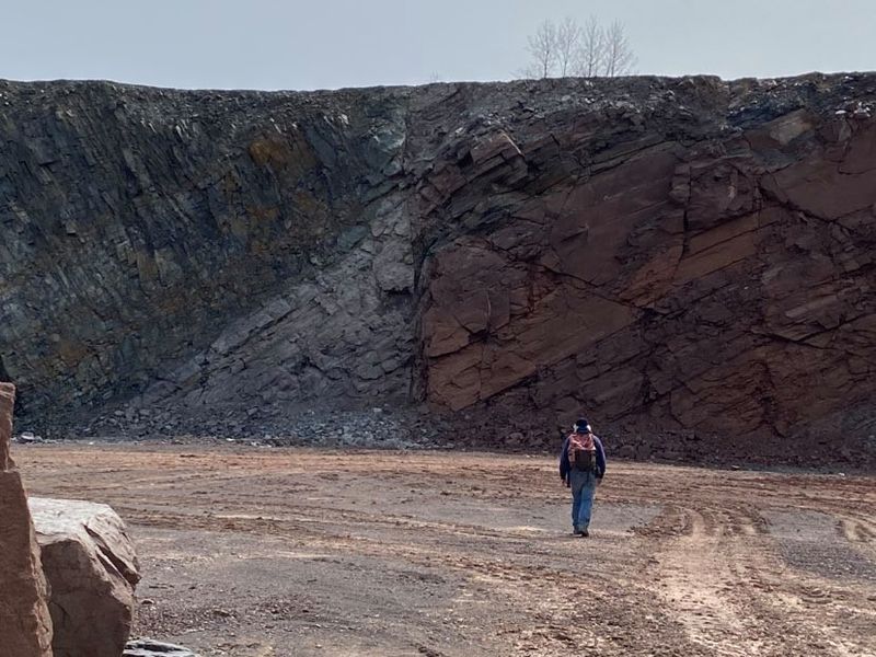
The ridge of the Mount Tom Range was formed 200 million years ago during the late Triassic and early Jurassic periods and is composed of traprock. Huge slopes of fractured basalt talus are visible beneath many of the ledges; they are particularly noticeable beneath Mount Tom, Whiting Peak, and Deadtop along the Mount Tom State Reservation park road, or along Metacomet-Monadnock Trail. The basalt ridges are the product of several massive lava flows hundreds of feet deep that welled up in faults created by the rifting apart of North America from Eurasia and Africa. These basalt floods of lava happened over a period of 20 million years. Erosion occurring between the eruptions deposited deep layers of sediment between the lava flows, which eventually lithified into sedimentary rock, complete with dinosaur trackways. The resulting "layer cake" of basalt and sedimentary sheets eventually faulted and tilted upward. Subsequent erosion wore away the weaker sedimentary layers faster than the basalt layers, leaving the abruptly tilted edges of the basalt sheets exposed, creating the distinct linear ridge and dramatic cliff faces visible today. The image shows the basalt overlaying the siltstone, red beds and the offset exposed by quarrying.
| Description: |
| Offset at the fault line of the Holyoke range. |
|
| Viewed: |
12816 Time(s) |
|
|
|
| Back to top |
|
 |
Chris Rayburn
Joined: 07 Oct 2013
Posts: 66
Location: Arvada, Colorado
|
| Posted: Apr 16, 2020 06:17 Post subject: Re: Mines and mineral Localities |
|
|
| Textbook
|
|
| Back to top |
|
|
Tony L. Potucek
Joined: 29 Dec 2006
Posts: 98
Location: Arizona
|
| Posted: Apr 16, 2020 08:14 Post subject: Re: Mines and mineral Localities |
|
|
Excelllent exposure, Vic, and thanks for posting it!
tlp
_________________
Tony L. Potucek |
|
| Back to top |
|
|
|